


Our plans for Land South of Hill Dyke Road
Welcome to the consultation website for Taylor Wimpey’s proposals for the site: ‘Land South of Hill Dyke Road, Wheathampstead.
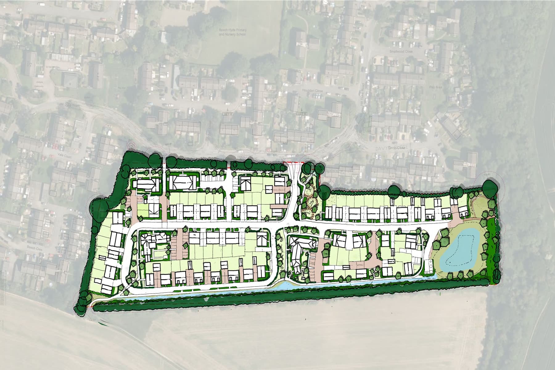
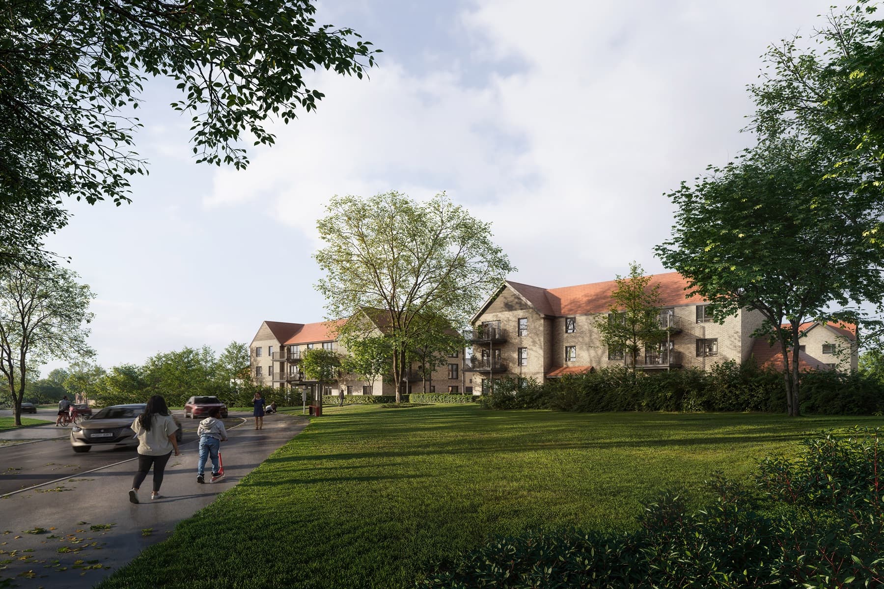
Taylor Wimpey has submitted proposals for 97 high-quality new and sustainable homes on this site – providing more affordable housing for Wheathampstead and the wider St Albans area, creating new public open spaces and making improvements to existing local services and transport routes for the community (precise details to be agreed with St Albans Council).
The application has been submitted and can be viewed by going to the St Albans Planning Portal and entering reference number: 5/2026/0751.
To continue to engage with the community, Taylor Wimpey is running an in-person information event on Thursday 14th May for the local community to drop-in any time between 5pm – 8pm. To view the detail on this event, please check the Latest Updates section.
You can view the proposals via the 'What's Proposed' tab and if you have any questions – please do contact us at: info@hilldykeroad.co.uk
Taylor Wimpey welcomes the community to attend an in-person information event. You will be able to view the submitted proposals and speak to members of the project team who will be able to provide the background and information about the project. The event will be:
Date: Thursday 14th May 2026
Time: 5pm – 8pm
Location: Hill Dyke Community Centre, 17 Hill Dyke Rd, Wheathampstead, St Albans AL4 8TU
If you have any questions about the proposals, please either call us on 0800 148 8911 or email us at info@hilldykeroad.co.uk. Alternatively, please write to us using the following address, FREEPOST Meeting Place Consultation.
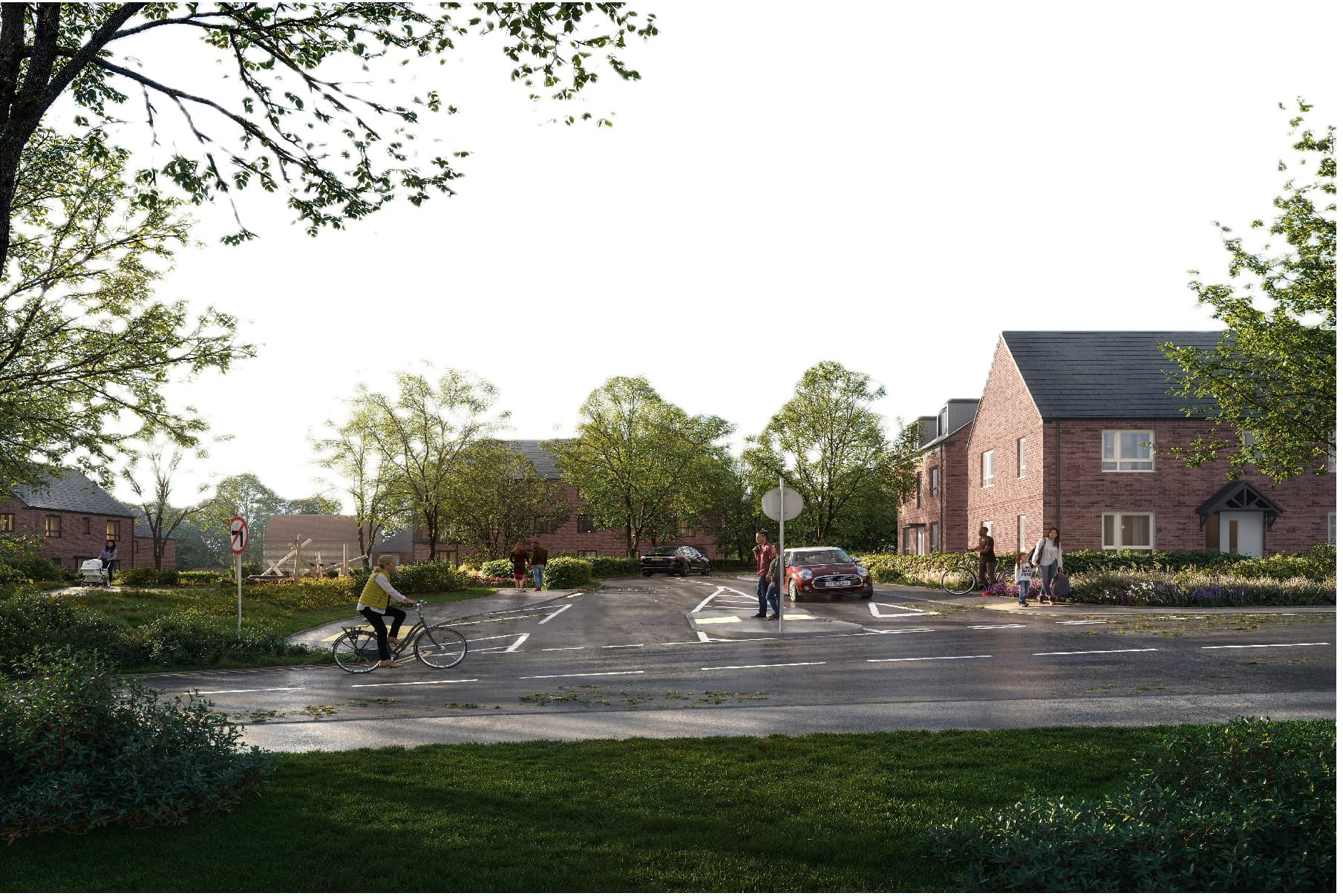
The site is located to the south east of Wheathampstead. Hill Dyke Road and nearby homes lie to the north of the site, with further homes located to the west. To the south is open countryside and to the east of the site is Dyke Lane, with woodland beyond. There are trees/vegetation along all boundaries of the site. The site is separated from the Scheduled Ancient Monument (‘SAM’) of the Belgic Oppidum and Devil’s Dyke by Dyke Lane. The proposed development will be designed to be no closer to the SAM than existing Wheathampstead.
The site is allocated for new homes in the emerging St Albans City and District Council’s Local Plan. In this new emerging Local Plan, which will seek to ensure that the District’s growth needs are sustainably managed, the site is allocation M2 – Hill Dyke Road, Wheathampstead.

- 97 high-quality new homes including 39 (40%) affordable homes.
- A mix of homes ranging from 1 bed to 5 bed to meet a diverse range of local housing need.
- EV charging for all homes.
- Landscaping and biodiversity improvements, with significant open public green space providing biodiversity net gain.
- A sustainable drainage system (SuDS) to manage surface water.
- Financial contributions to public infrastructure including local education, transport and health services.
As part of this scheme, Taylor Wimpey has submitted a landscaping strategy that proposes green spaces onsite and opens previously private land into public use. This strategy:
- Identifies how much new public open space will be delivered and any publicly accessible features like play areas to foster community activities and recreational opportunities.
- Demonstrates how the proposals meet the Council’s requirement of a 10% biodiversity net gain on all new planning applications.
- Shows any publicly accessible routes to other locations or through the development.
- Retains existing treelines and hedgerows.
It is part of St Albans City and District Council’s planning policy to ensure any site is sustainable and conforms with the council’s planning policies on sustainability, environmental protection and biodiversity. This application will do this in a number of ways including (though not limited to):
- New habitats will be created both on-site and off-site which will result in a 10% biodiversity net gain.
- Installation of electric vehicle charging points for more sustainable travel.
- Using the latest building practices such as air source heat pumps and housing insulation to reduce heat loss.
As part of the application, Taylor Wimpey commissioned a dedicated team of transport consultants to assess local transport movements on the site and in the surrounding area. Taylor Wimpey have submitted a transport assessment as part of the planning application which details how traffic impacts will be minimised.
This includes assessments of current traffic trips and movements as well as projected trips based on the housing numbers and expected visitors to the site. The trips have been taken from existing roads that directly service this development.
Subject to discussions with the Local Highway Authority (Herts County Council), Taylor Wimpey will be required to facilitate or contribute towards improvements to local highways, where necessary to make the proposed development acceptable.
Sustainable transport
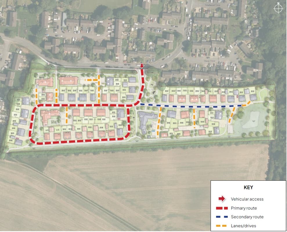
The proposals include a dedicated pedestrian network design to connecting up existing sustainable transport options – such as the local bus stop. The site will provide connections to the existing Public Rights of Way (PROW) to the southwestern corner and to Devil’s Dyke to the east. All new properties will be provided with dedicated secure cycle storage with links to the national cycle network to the north and East.
Access
Vehicular access to the site is to be provided from Hill Dyke Road via a new junction, with appropriate width cycle/ footways either side for safe pedestrian access. There will also be additional pedestrian links to Hill Dyke Road along the northern boundary.
Parking strategy
The on-site parking has been designed to work with the street scene, providing a mix of parking courts, private driveways and on-street parking. On street parking will be limited to visitor parking bays with private bays and parking courts available for resident parking. This will maintain defined areas for street parking and is designed to keep streets clearer.
Your questions answered
1. Where is the site?
The site is located to the south east of Wheathampstead. Hill Dyke Road and nearby homes lie to the north of the site, with further homes located to the west. To the south is open countryside and to the east is Dyke Lane, with woodland beyond. There are trees/vegetation partially along all boundaries of the site.
2. Is this site proposed to be developed in the new Local Plan for the district?
Yes, the site is proposed to be allocated for housing development in St Albans City and District Council’s Local Plan, which is currently being heard at examination. The site is considered as a draft allocation in the Regulation 18 stage of the Local Plan under policy reference ‘site M2 – Hill Dyke Road, Wheathampstead’. The proposed use is for approximately 85 homes. The proposed scheme proposing a mix of both houses and apartments and delivers 95 homes.
3. Why is the District Council proposing the allocation of this site for residential development?
The new Local Plan is supported by a detailed evidence base which considers the suitability and deliverability of various options to accommodate the district’s development needs.
The site has been considered through this process and found to be suitable and sustainable to help meet housing needs.
Key factors include the lack of constraints on the site (e.g. it is not in an area of flood risk, it is not identified as being ecologically important, etc.). Additionally, the site makes a relatively limited contribution to the Green Belt and can be developed in a way that ensures a new, robust, long-term Green Belt boundary. A further consideration is that it is well-located in relation to a number of services and facilities, helping to reduce reliance on travel by car.
4. Why do we need more homes in the district?
Additional housing is needed across the UK to tackle severe social problems linked to overcrowding, affordability and homelessness, which are now affecting hundreds of thousands of households and are driven in substantial part by under delivery of housing.
High rents and house prices that have grown much faster than wages are pushing low‑ and middle‑income households into overcrowded, insecure private renting or temporary accommodation, with nearly 300,000 families and individuals in England now experiencing the most acute forms of homelessness and around 1.5 million households on social housing waiting lists. These pressures damage physical and mental health, disrupt children’s education, entrench poverty, and increase public spending on temporary accommodation instead of stable, long‑term homes.
In St Albans, these national issues are intensified by very high local house prices and rents, which make the area unaffordable for many key workers, younger households and lower‑income families, and drive sustained demand for social and affordable housing.
The council’s Housing Strategy identifies consistent pressure on social housing, increased need for family‑sized homes, and rising demand for temporary accommodation for homeless households, while local advice agencies report a lack of social housing, insufficient affordable options in the private rented sector and acute financial strain on households due to housing costs.
Currently, St Albans is not meeting the government’s housing delivery requirements, and cannot demonstrate a 5-year housing land supply, which is required by national planning policy to ensure housing needs are being met.
To meet these important national requirements and ensure local people can afford to live within the district, St Albans City and District Council needs to find more sustainable, deliverable housing sites, such as this one, to be granted planning permission.
5. What are you proposing for this site?
At this stage, the proposals currently include:
- 95 high-quality new homes including 38 affordable homes.
- Mix of homes ranging from 1 bed to 5 bed to meet a diverse range of local housing need.
- EV charging available for all homes.
- Landscaping and biodiversity improvements, providing at least 10% biodiversity net gain.
- A sustainable drainage system (SuDS) to manage surface water.
- Significant landscaped public open space, including play space
6. Does this scheme provide affordable housing onsite?
Yes, the application will provide 40% affordable housing to meet the threshold for St Albans affordable housing strategy.
The mix of unit type, size, and tenures will be agreed with St Albans through the planning application process to ensure it best reflects local needs. The affordable housing will likely include a combination of social and affordable rent, affordable home ownership and shared ownership properties.
7. What do you mean by affordable housing? Will it be genuinely affordable and for existing residents?
Affordable housing provides a range of options for people with different requirements. Affordable housing can mean social housing – such as council housing – which is managed by a registered housing provider. Other forms of affordable housing include shared ownership – where multiple owners can buy a share of a house and therefore pay less money to get on the property ladder. This opens up home ownership for a wider range of people than would have been able to previously. These affordable options are designed to allow different people to find the housing that suits them best.
The Council needs to unlock new sites which provide affordable housing which will ultimately add more affordable housing stock and reduce waiting lists in the District.
These proposals will provide a range of affordable housing options which will be agreed with the Council before construction.
As part of pre-application discussions with the local community, we would be keen to hear what forms of affordable housing are considered to be most needed in the area.
8. How will impact on infrastructure be managed.
These proposals will be providing S.106 contributions which are infrastructure payments agreed with the Council. Any infrastructure payments that the Council require will be assessed through dialogue with the developer through the planning process and will be agreed ahead of any planning permission being issued or construction commencing. Contributions are likely to include payments towards:
- Local health services
- Landscaped public open spaces including sports and play areas in the district
- Highways and public transport
- Recreational facilities
- Education
9. Are you making sure this site is sustainable? How are you achieving this?
It is part of St Albans’ City Council’s planning policy to ensure that any site is sustainable and conforms with the council’s planning policies on sustainability, environmental protection and biodiversity.
This application will do this in a number of ways including (though not limited to):
- New habitats will be created which will result in a 10% biodiversity net gain.
- Installation of electric vehicle charging points for more sustainable travel.
Latest building practices such as air source heat pumps and housing insulation to reduce heat loss.
10. How will this scheme affect local transport in the area?
As part of the application, Taylor Wimpey has commissioned PJA transport consultants to assess local transport movements on the site and in the surrounding area and will submit a transport assessment as part of the planning application which will detail how traffic impacts are to be minimised.
This will include assessments of current traffic trips and movements as well as projected trips based on the housing numbers and expected visitors to the site. The trips will be taken from existing roads that directly service this development.
11. How will you prevent congestion as a result of any increased traffic from this development? Are there any plans to manage the traffic speed on the surrounding network?
Junction capacity modelling has been undertaken on the Hill Dyke Road/B651 Junction which demonstrates the junction operates well within capacity. Nevertheless, it is understood that there is some concern within the local community of high vehicle speeds along the B651 in the vicinity of the junction. This has been highlighted as an issue within St Albans Local Plan.
As such, as part of the development proposals, investigation is being made into improvements that can be made to the B651 to reduce vehicle speeds. Discussions are taking place with Hertfordshire and St Albans Council’s as to what form these improvements will take and how they will be implemented.
A Travel Plan will also be produced for the development which will set out targets and initiatives for reducing vehicle trips and increasing walking, cycling and public transport use. This will be agreed with HCC, with its performance monitored yearly. This will help the development reduce its impact on the surrounding highway network.
12. How will the new access be accommodated into the existing transport network?
As part of the transport assessment, the proposed access will be modelled with anticipated trips to and from the site with measures to demonstrate how the access will be properly managed and promote safe travel.
The draft allocation in the Local Plan says the site has direct access onto Hill Dyke Road. The main site access must connect north on to Hill Dyke Road. Access on to Dyke Lane to the east must be for pedestrians and cyclists only and not for vehicles.
Taylor Wimpey will work with Herts County Council to agree a transport solution to reduce any undue impact from this development on the local highways network.
13. Will there be any flooding risks because of this development?
As part of the application, Taylor Wimpey will assess any existing and potential flood risk onsite.
A detailed flood risk assessment will be submitted as part of a future planning application and will identify any measures necessary to make sure that the development would not increase the risk of flooding on the site or elsewhere.
National policy requires us to improve upon surface water run-off rates compared to existing conditions, taking into account future climate change effects on rainfall.
The proposed development comprises swales and basins to manage surface water and ensure the development will not cause local flooding.
14. Will you be reviewing local sewage capacity as part of this development?
Yes, as part of this outline application, Taylor Wimpey will conduct its own survey into local sewage capacity to check to see whether there is capacity in the existing network and whether Taylor Wimpey will need to ensure improvements prior to development. Water companies may be required to ensure that their infrastructure is upgraded, and the site has been identified by the Council now for a number of years as a potential one to provide new homes, including in consultation with water companies.
This will be confirmed once the application is submitted and St Albans Council will contact Herts County Council and Affinity Water ahead of granting planning permission to confirm they are happy with the proposals.
15. How are you consulting with the local community?
The project team previously ran an in-person and online public exhibition event. This included a public consultation event held at the Hill Dyke Community Centre on Thursday 5th February 2026 between 3pm – 7pm. Exhibition banners and plans were available, with members of the team on hand to answer any questions. Feedback forms were also available for residents to provide their comments.
The application has now been submitted and can be viewed on the St Albans Planning Portal by entering reference number: 5/2026/0751
The project team is also holding an information event at the Hill Dyke Road Community Centre, the details of which can be viewed below:
Date: Thursday 14th May 2026
Time: 5pm – 8pm
Location: Hill Dyke Community Centre, 17 Hill Dyke Rd, Wheathampstead, St Albans AL4 8TU
If you have any questions about the submitted proposals or the information event, please use the contact details below:
- Freephone number: 0800 148 8911 (Available Monday–Friday, from 9am–5pm)
- Email: info@hilldykeroad.co.uk
- Freepost address: Freepost MEETING PLACE CONSULTATION
This pre-application consultation is separate from and in addition to that which the District Council will be required to undertake once an application is submitted.
16. When are you proposing to submit a planning application?
The application has now been submitted and can be viewed on the St Albans Planning Portal by entering reference number: 5/2026/0751
17. How can I comment on the planning application?
 Learn more
Why choose us?
We're one of the UK's largest homebuilders. Find out why to choose us for your new home.
Learn more
Why choose us?
We're one of the UK's largest homebuilders. Find out why to choose us for your new home.
 Ways to buy
Help with buying your new home
Explore the ways we can help get your home buying journey moving.
Ways to buy
Help with buying your new home
Explore the ways we can help get your home buying journey moving.
 Why choose us
Award winning homes
We're proud to have been awarded 5 stars for customer satisfaction by the Home Builders Federation.
Why choose us
Award winning homes
We're proud to have been awarded 5 stars for customer satisfaction by the Home Builders Federation.